
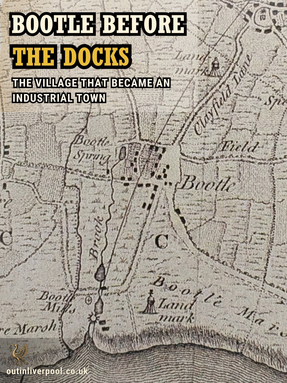
An Extraordinary Glimpse of Bootle in 1793
In August 1793, an advertisement appeared in the Liverpool Advertiser offering a remarkable collection of property for sale at Bootle Coffee House. There was a windmill, the site of a watermill, a house, gardens and approximately 18 acres of land near the River Mersey. The premises were held on a lease from the Earl of Derby, and the advertisement praised the abundant freshwater supplied by Bootle's natural springs. It suggested that the water could be used for manufacturing fine paper or powering cotton-spinning machinery.
But another detail seems almost unimaginable today. The property was also advertised as an attractive place for sea bathing, already frequented by visitors. Here, in one eighteenth-century advertisement, was a Bootle that scarcely resembles the industrial town that followed: mills rather than dockside warehouses, open land instead of tightly packed residential streets, and a shoreline where people came for recreation.
The advertisement survives through a transcription published in Bennett and Elton's History of Corn Milling and subsequently reproduced in the Bootle Free Library, Museum and Technical School Journal. It captures a moment when Bootle stood between two very different futures: a rural settlement becoming increasingly attractive for leisure, and a place whose natural resources might support industry.
Within a century, that familiar landscape would be transformed almost beyond recognition. But Bootle's history had already been unfolding for hundreds of years.
1. Boltelai — The Village Before Liverpool's Borough
Bootle appears in the Domesday Book of 1086, the great survey commissioned by William the Conqueror to record England's landholdings and their value. The settlement appears under the name Boltelai, with later spellings including Botle, Botel and Bothull. Its name is generally derived from the Old English bōtl, meaning a dwelling or house. The derivation suggests Anglo-Saxon origins, although it does not establish precisely when people first settled there.
Domesday recorded four manors held by four thegns before the Norman Conquest. These were men of recognised status within Anglo-Saxon society, whose landholding involved rights and obligations. The entry also recorded agricultural land associated with the church at Walton. The four manors should not be imagined as four grand houses standing within the present-day town: Domesday was concerned primarily with ownership, obligations and taxable resources, not providing a description of individual buildings.
What the record establishes is that Bootle was a recognised settlement by the eleventh century. Liverpool itself was not recorded by name in Domesday, although that should not be interpreted as proof that its later site was unoccupied. Liverpool received its borough charter in 1207, when King John sought to develop the settlement as a port. Bootle therefore had a documented history before Liverpool emerged as a chartered borough.
Landowners, tenants and working land
During the Middle Ages, Bootle's estates passed through several families, including the descendants of Roger, son of Ravenkil, and members of the Beetham family. Landholding was frequently complicated by inheritance, marriage and the division of property between heirs. Documents recorded rents, the value of agricultural land and obligations owed to landlords, but they tell us far less about the everyday lives of the people farming the fields.
Bootle was part of a landscape of cultivated ground, meadows, tracks and streams. Rural households depended upon agriculture and the activities that accompanied it, although there is insufficient evidence to reconstruct the entire medieval village, identify every occupation or establish the exact number of inhabitants. One surviving record, however, reveals something significant about its economy: by 1254, Bootle possessed a documented watermill.
An inquisition concerning Sir Ralph de Beetham, who died in that year, recorded his interest in the mill. His holding included five-sixths of the watermill, valued at five marks annually, while the remaining sixth was associated with the Stockport family's property interests. This divided ownership reflected the complex nature of medieval landholding, when a mill was a valuable asset rather than simply a building containing machinery.
Watermills typically provided a means of grinding agricultural produce, especially grain, and their operation could generate income through milling rights and charges. The record is therefore evidence of productive activity within medieval Bootle, although it does not prove that the same mill building survived for hundreds of years or establish the precise site of the 1254 structure. Nevertheless, mills would remain important to Bootle's history, largely because of something the settlement possessed in abundance: fresh water.
2. A Village Built Around Water
The old village developed inland from the Mersey, around the area occupied today by Merton Road, Litherland Road, Hawthorne Road and neighbouring streets. Its location was closely connected with natural freshwater springs, including the principal spring associated with the vicinity of today's Well Lane. Water shaped the landscape, powered milling operations and supported trades that required a dependable supply. Sefton's historical conservation research identifies papermaking, tanning and bleaching among the water-dependent industries associated with the district.
Bootle was therefore never exclusively agricultural. The historical maps reveal a settlement whose economy was becoming increasingly varied, even before the great dock expansion.
An eighteenth-century map discussed in Sefton's conservation research shows Bootle as a compact settlement of approximately 26 buildings. The lanes that would become Merton Road, Litherland Road, Hawthorne Road and Breeze Hill were already recognisable, with open land stretching beyond them. The 1839 tithe map shows clusters of enclosed plots, known as crofts, surrounded by farmland, while the waterworks occupied land to the north of the original settlement. By the first Ordnance Survey mapping of 1851, the landscape contained a tannery, chemical works, inns and a sandstone quarry in addition to the village buildings.
These maps allow us to reconstruct the outline of old Bootle and follow the gradual disappearance of its rural surroundings. They cannot reveal every activity taking place within the village, but they demonstrate that industrial development was already under way before the docks became its dominant feature.
Bootle Mills and the arrival of new technology
By the late eighteenth century, Bootle's milling operations included both water and wind power. Bennett and Elton's history of corn milling records a windmill erected near the older watermill in 1789, while the same history reproduces a notice from the Liverpool Advertiser of January 1791 offering a relatively new steam engine and waterwheel for sale at Bootle.
According to the later account, steam machinery had been introduced in an attempt to improve the mill's operation, but the experiment was unsuccessful and the equipment was subsequently offered for sale. This does not make Bootle a pioneer of successful steam-powered industrial production, but it does show that those managing the mills were responding to changing technology.
Two years later came the 1793 advertisement offering the windmill, watermill site and surrounding land. The spring water was being promoted as a resource for manufacturing development, and the property's commercial potential was clearly part of its appeal. The claims made in the advertisement should be understood as those of a seller rather than independently measured engineering performance, but they reveal how valuable access to water had become.
The water that Liverpool needed
Meanwhile, a larger opportunity was developing. Liverpool's expanding population and commercial activity created an increasing demand for fresh water, and Bootle's springs offered a potential solution. A plan dated 1798 survives showing a proposed pipeline from Bootle towards Liverpool. In 1799, Parliament passed the Liverpool Water Supply Act, authorising the supply of the town and port from springs in the township of Bootle.
Some local histories date the establishment of the Bootle Water Company to 1797, while others use 1799. The distinction between initial organisation and statutory authorisation is not entirely resolved, although parliamentary powers were firmly established in 1799. The company became part of Liverpool's developing water infrastructure, and Bootle's supply continued to feature in the city's water arrangements during the following decades.
There was, however, an important consequence for the village itself. A contemporary account of Bootle's municipal incorporation, later reprinted in its public library journal, claimed that diverting the springs' water for Liverpool had damaged water-dependent industries in Bootle. The account presented this as a serious loss to the village economy, although the scale of the damage cannot be established solely from that report.
The relationship was therefore not simply one in which a growing Liverpool brought prosperity to its neighbour. Liverpool needed Bootle's water, but exploiting that resource could also affect the industries already using it. The later expansion of the docks would create another, much larger transformation, although before that happened Bootle's coastline had acquired a rather different reputation.
3. When Bootle Was a Place to Visit the Seaside
It may be difficult to picture today, but Bootle and neighbouring Linacre once attracted people who came to enjoy the beach, sea air and bathing. The waterfront had not yet been enclosed by the vast northern dock estate, and the coastline included sands and shoreland with views across the Mersey estuary. By the late eighteenth century, bathing in the sea was becoming increasingly fashionable, promoted for health as well as recreation. Bootle's proximity to Liverpool made the coast accessible to people seeking relief from the crowded town, with some visitors staying in villas or lodging houses while others made shorter excursions.
An important geographical distinction is that Bootle village and Linacre were historically separate settlements. Linacre's older centre lay around today's Linacre Lane and Linacre Road, and its name, recorded as Lynaker in 1212, is generally interpreted as meaning a flax field. The settlement had historical connections with Bootle's manor but retained a separate identity, and much of the coastal resort development was associated with shoreward land around Linacre. Contemporary descriptions sometimes discuss the two places together, so it would be misleading to place every beach, villa or bathing establishment within the original Bootle village.
An 1812 visitor's guide described the summer experience of travelling along the sands, praising their surface and the refreshing winds. Edward Baines' 1824 directory described Linacre as a marine village popular with summer visitors, while accounts from the following decades mention villas, bathing and the growing residential attraction of the coast.
The seaside was not necessarily enjoyed by one social class alone. An 1855 description quoted in Sefton's conservation appraisal depicts large numbers of people travelling from Liverpool to bathe, although its language reflects the prejudices and attitudes of the period. Such accounts suggest a shoreline serving both more prosperous residents and a broader visiting public.
There was also a social world associated with Bootle Coffee House. A historical article published in the Bootle Free Library Journal in 1900 describes an informal organisation of Liverpool gentlemen known as the Mock Corporation of Sefton, whose winter meetings were held at Bootle Coffee House from the 1780s. The coffee house was therefore more than an address in a property advertisement: it formed part of the area's social life.
By the middle of the nineteenth century, however, the character of the shoreline was changing. The demands of a growing commercial port would eventually prove more powerful than the attractions of the seaside.
4. How the Docks Changed the Landscape
Bootle's transformation did not begin with a single dock opening. It developed through successive changes in transport, commerce, housing and industry, beginning well before the northern waterfront became dominated by shipping facilities.
The Leeds and Liverpool Canal provided an important connection during the 1770s, although the full canal across the Pennines was not completed until 1816. Passing close to the village, it improved access to Liverpool and other destinations. The railway followed, with the Southport and Waterloo connection opening in 1848 and through services towards Liverpool developing in 1850. Bootle Village Station, near Merton Road, helped make the district accessible to commuters and visitors.
These transport improvements encouraged residential development. Merchants, professional families and other relatively prosperous residents were attracted to houses along Merton Road, Trinity Road and neighbouring streets. Yet the decisive change came from the docks, whose expansion would transform both the economy and the physical geography of the district.
Liverpool's expanding northern waterfront
As Liverpool's shipping trade increased, its dock system extended northwards along the eastern bank of the Mersey. Canada Dock opened in 1859 and Brocklebank Dock followed in 1862. Further major developments included Alexandra and Langton docks, opened in 1881, followed by additional facilities during the later nineteenth century.
These works required extensive land, quays, warehouses, transport connections and industrial infrastructure. Parts of the coastline were reclaimed, altered or enclosed, while railway sidings and roads provided access for the movement of goods. The sands that had attracted bathers became progressively inaccessible as the working port spread.
The docks were operated as part of Liverpool's port system, but their expansion into Bootle did not mean that Bootle ceased to exist as a distinct settlement or later borough. This was the growth of a major port across neighbouring territory, with profound consequences for the people living there.
The effects can be followed through historical maps. In 1851, Bootle's village centre was still recognisable, but by the 1890s much of the surrounding farmland had disappeared beneath streets of houses, shops and industrial premises. Waterworks Street, Gloucester Road, extensions of Hawthorne Road and other streets developed rapidly, replacing open ground with an increasingly dense urban landscape.
Some roads contained substantial houses standing in spacious plots, while others were filled with smaller terraced properties built to accommodate the growing workforce. These contrasting streetscapes reflected differences in income, occupation and social standing.
Bootle's industries included timber-related businesses, warehousing, dock services, manufacturing and trades serving the expanding urban population. The docks generated employment far beyond the men loading and unloading ships, requiring transport workers, clerks, tradesmen, warehouse staff, merchants and businesses supplying the port. The old village was becoming part of a much larger industrial economy.
A population transformed
The scale of change is visible in the population figures. In 1801, Bootle-cum-Linacre had only 537 inhabitants; by 1851 there were 4,106, and in 1861 the total stood at 6,414. Ten years later, in 1871, it had reached 16,247.
Municipal records later gave an 1881 population of 27,374, although some other published sources differ slightly. By 1891, the total had reached approximately 49,200. These figures represent more than physical expansion: they reflect thousands of people arriving, establishing households, finding employment and creating new communities.
Bootle attracted migrants from Ireland, Wales and Scotland as well as other parts of England. The town's religious buildings, schools, businesses and social organisations reflected this increasingly varied population. Welsh builders played a documented role in its nineteenth-century housing development, with Sefton's conservation research identifying William Jones as one of the builders associated with housing around Hawthorne Road during the 1860s.
Jones subsequently settled in Bootle and served as its mayor, while his later home at 9 Merton Road is identified in the conservation appraisal. His career provides a revealing example of the town's transformation: men who came to develop Bootle's streets could themselves become part of its civic leadership.
At the same time, growing numbers of working families needed homes close to the docks, factories and transport routes. Housing construction struggled to keep pace with population growth, and overcrowding and public-health problems became important concerns. Opportunities for employment and commercial success existed alongside cramped housing, pressure on local services and the loss of former open spaces.
The new Bootle offered economic possibilities that the agricultural village could never have provided on the same scale. It also demanded a new form of government.
5. Bootle Becomes a Borough — And Defends Its Identity
On 30 December 1868, Bootle-cum-Linacre received its charter of incorporation as a municipal borough. It was an important milestone, and one that is sometimes misunderstood. Bootle was not incorporated into Liverpool: it became a borough in its own right, with its own mayor, aldermen and elected councillors.
The original charter and contemporary reports of its arrival were reproduced in the Bootle Free Library, Museum and Technical School Journal in 1900. Those reports convey something a simple date cannot. In January 1869, a deputation returned from London carrying the charter, and crowds and a brass band greeted the party near the boundary with Liverpool. A procession passed through the township before the document was publicly read, with celebrations continuing at a dinner in the Dolphin Hotel.
The arrival of the charter was therefore treated as a major public occasion rather than merely an administrative adjustment. The new borough represented Bootle's growing confidence and its determination to manage its own affairs.
Municipal development accelerated during the following decades. Bootle Town Hall and Public Offices opened in 1882, marking the growth of a new civic centre around Oriel Road and Balliol Road. Under the Local Government Act 1888, Bootle became a county borough from 1 April 1889, taking on wider responsibilities for local government. The town developed public institutions, including educational facilities, libraries and recreational amenities.
Its separate identity continued to matter. In July 1903, a parliamentary proposal to include Bootle within Liverpool was rejected, and Bootle remained an independent county borough until the local-government reorganisation of 1974, when it became part of the newly created Metropolitan Borough of Sefton.
This administrative history should not be confused with Bootle's economic relationship with Liverpool. The two places were closely connected by docks, trade, transport and employment, but Bootle had its own institutions, political history and civic identity.
The price of losing the foreshore
Perhaps the most powerful evidence of how Bootle experienced industrialisation comes from its own council. In March 1890, councillors considered the growing need for a public park, and the discussion was later reproduced in Sefton's Derby Park Conservation Area Appraisal.
The council recognised the rapid transformation of Bootle from an attractive residential district into a busy industrial town. Councillors worried about the disappearance of open land as building continued and, most strikingly, acknowledged that the Dock Board's appropriation of the foreshore had deprived residents of a recreational place enjoyed for generations.
This was a contemporary recognition of loss. The coastline that had once attracted bathing visitors was no longer available in the same way, and the industrial town needed new spaces where residents could enjoy fresh air and recreation.
There was another motive, too: civic ambition. A substantial public park would be a visible expression of Bootle's municipal status and confidence. Yet the proposal was not universally welcomed, with Sefton's appraisal recording concerns among some that a new park might attract supposedly undesirable visitors from Liverpool. Those attitudes reveal something about class, social boundaries and the relationship between the neighbouring towns.
Derby Park — A new landscape for a changing town
The council approached Frederick Arthur Stanley, the 16th Earl of Derby, seeking land for a public park. By 1891, he had agreed to provide approximately 22 acres of agricultural land east of the former village. Work began in 1893, with the layout designed by Borough Surveyor William Nisbet Blair, and Derby Park opened on 17 August 1895.
The park was not a restoration of Bootle's lost beach. It was a new kind of public landscape created for an urban population, with promenades, planting, paths and recreational facilities reflecting Victorian ideas about public health, leisure and civic improvement. It also occupied ground that had formerly formed part of Bootle's rural surroundings.
There is a compelling continuity in that history. A town that had lost much of its coastline to industrial expansion used former agricultural land to create a new public place. Derby Park remains one of the clearest surviving expressions of Bootle's Victorian civic ambition.
6. Finding the Old Village in Modern Bootle
Much of pre-industrial Bootle has disappeared. The medieval watermill no longer stands, the former bathing coastline has been transformed, and the agricultural land around the village was progressively developed. The springs that once helped determine the settlement's location are not readily identifiable as visible above-ground features. Nevertheless, the old Bootle can still be traced through historic buildings, street patterns, surviving names and the evidence preserved in historical maps.
Old Hall and the former village centre
Two of the most important surviving buildings stand at Nos. 1 and 3 Merton Road. No. 3, known as Old Hall, was originally associated with the Earl of Derby as a shooting lodge. Historic England records a rainwater head bearing the Derby family's crest and the date 1773, although the building was altered during the nineteenth century and the date should not automatically be taken as the original construction date of every part of the structure.
Next door, No. 1 Merton Road was formerly associated with the lodge's kitchen wing. Both buildings are Grade II listed, providing tangible reminders of Bootle before the great urban expansion.
The historic village centre occupied an area around Merton Road, Litherland Road, Hawthorne Road and the neighbouring street network. Sefton's conservation appraisal identifies surviving elements of the older, less regular road pattern, an important reminder that traces of a settlement do not always take the form of ancient buildings.
Road alignments, boundaries and the positions of later structures can preserve evidence of how an earlier place developed. The contrast is particularly noticeable when the older village area is compared with the more regular nineteenth-century streets surrounding it.
Well Lane and Waterworks Street also preserve names associated with Bootle's freshwater history. They offer clues to a landscape in which springs, millponds and water-dependent trades once played an important role, even though the original water features are no longer obvious in the modern streetscape.
The Victorian town layered over the village
Other surviving buildings tell the story of the next period. Historic villas and houses along Merton Road reflect the area's attraction to more prosperous residents during the nineteenth century, while former industrial buildings around Well Lane and Waterworks Street demonstrate how manufacturing developed alongside housing. Derby Park, with its designed landscape and surviving historic features, represents the new civic town.
None of these should be mistaken for an intact medieval village. Their importance lies in showing how successive periods of development altered the same landscape.
A useful way to understand the district is to compare the 1839 tithe map with the first Ordnance Survey mapping and the later nineteenth-century editions. The sequence reveals where fields were enclosed, where roads appeared and how the original village became part of a much larger urban settlement.
Bootle's past survives not as a single preserved historic quarter, but as overlapping evidence of different periods.
A Town With a Much Longer Story
Bootle's industrial and maritime history is fundamental to its identity. The docks brought employment, attracted new communities and helped transform the town into an important part of the Mersey's working waterfront. But that familiar story is only the later chapter of a much longer history.
The Bootle recorded in Domesday already had a recognised place in the landscape. Its medieval watermill demonstrates an economy shaped by natural resources long before steam engines or dock machinery arrived. Its springs supplied water to Liverpool, its shoreline attracted bathers, and its farms, mills and lanes formed the nucleus of a settlement that would eventually be overtaken by urban development.
That transformation brought jobs, housing, institutions and new opportunities, but it also brought serious pressures and the loss of landscapes people had enjoyed for generations. Bootle's own council recognised those changes and responded by creating new civic spaces and services.
Today, the story can still be followed through old maps, surviving buildings, street patterns and the places whose names preserve a memory of the earlier village. The docks did not create Bootle; they transformed a place that already had centuries of history.
Before Bootle became a town shaped by ships, it was a village shaped by water.
Historical Sources and Further Reading
1. Sefton Historic Settlement Study (2011)
National Museums Liverpool and English Heritage, Merseyside Historic Characterisation Project. The core archaeological and historical assessment of Bootle and Linacre, including settlement origins, place-names and map evidence.
https://archaeologydataservice.ac.uk/catalogue/adsdata/arch-1144-1/dissemination/pdf/Sefton_HLC_report/Sefton-Part-6.pdf
2. Derby Park Conservation Area Appraisal (2007)
Sefton Metropolitan Borough Council. Principal source for the old village footprint, waterworks, housing expansion, historic buildings, Derby Park and the council's 1890 discussion of the lost foreshore.
https://www.sefton.gov.uk/media/2022/derby-park-conservation-area-appraisal.pdf
3. Derby Park Conservation Area Appraisal — Historic Maps Appendix
Sefton Council. Contains references and reproductions of historic maps, including the 1768 settlement plan, the 1798 pipeline proposal, the 1839 tithe map and later Ordnance Survey editions.
https://sefton.gov.uk/media/2023/ca-appraisal-appendix.pdf
4. A History of the County of Lancaster, Volume III (1907)
Edited by William Farrer and J. Brownbill. The township history and medieval landholding references, including the 1254 inquisition and watermill.
5. Bootle Free Library, Museum and Technical School Journal, Volume II (1900)
Edited by Charles H. Hunt and John J. Ogle. An important local publication containing historical material about Bootle Coffee House and the watermill, the 1868 charter and contemporary accounts of its arrival.
https://archive.org/details/journal2190boot
6. Bennett and Elton, History of Corn Milling, Volume IV (1904)
Historical account of Bootle Mills and the transcribed Liverpool Advertiser notices from 1789, 1791 and 1793. The newspaper originals have not been independently examined in this research.
7. Liverpool Water Supply Act 1799
39 Geo. III, chapter xxxvi. Parliamentary authority for supplying Liverpool with water from Bootle's springs.
https://www.legislation.gov.uk/gbla/Geo3/39/36/contents/enacted
8. Historic England — Old Hall, 3 Merton Road
National Heritage List entry 1198898, Grade II.
https://historicengland.org.uk/listing/the-list/list-entry/1198898
9. Historic England — 1 Merton Road
National Heritage List entry 1075890, Grade II.
https://historicengland.org.uk/listing/the-list/list-entry/1075890
10. Historic England — Derby Park
National Heritage List entry 1001642, Grade II registered park.
https://historicengland.org.uk/listing/the-list/list-entry/1001642
11. Sefton Digital Archive — Bootle
Sefton Library and Local Studies collection of historical photographs, illustrations and local-history material.
https://sefton-digital-archive.org/archive/sefton-looking-back/townships/bootle
12. Encyclopaedia Britannica, Eleventh Edition (1911), Bootle
Contemporary reference recording Bootle's borough history and the rejection of a proposal to incorporate it into Liverpool in July 1903.
https://en.wikisource.org/wiki/1911_Encyclop%C3%A6dia_Britannica/Bootle
Research qualifications: The 1793 mill advertisement and March 1890 council proceedings are known through documented later reproductions. Some historical population totals differ between sources, and the founding date of the Bootle Water Company requires distinction from its 1799 parliamentary powers. These matters have been qualified in the text rather than presented as undisputed facts.
Continue the conversation
Share this Bootle story
What traces of old Bootle have you noticed, or what memories of the town would you add?