There is a moment when a map stops looking like a record of the past and starts looking like a warning of what is about to happen.
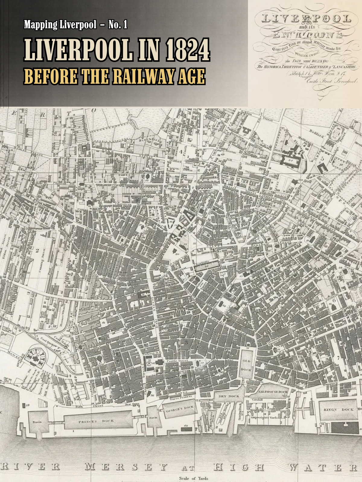
William Swire’s 1824 map of Liverpool is one of those maps.
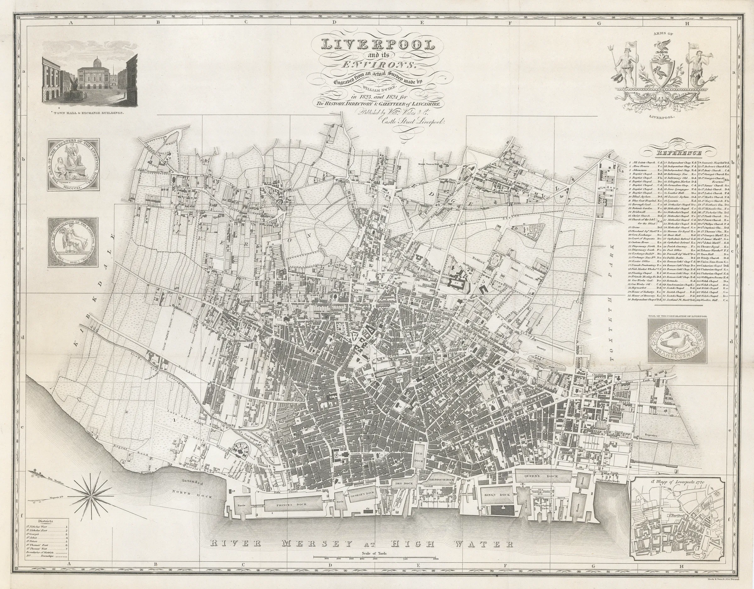
The town is already crowded against the Mersey. Docks line the waterfront. Streets push outward from the old centre. The Leeds–Liverpool Canal reaches the northern edge. Yet beyond the dense streets are still fields, gardens and separate settlements.
Everton is still visibly apart.
The Botanic Garden sits beyond the tightly built town. The Old Dock — the great enclosed wet dock that had helped transform Liverpool after 1715 — is still there.
And there is something else missing.
The railway.
The Liverpool & Manchester Railway would not open until 15 September 1830. Swire therefore caught Liverpool just six years before one of the great transport revolutions of the nineteenth century began reshaping the city again. [6]
That makes this a perfect place to begin our numbered Mapping Liverpool series.
Not simply because the map is beautiful.
Because it catches Liverpool in transition.
THE MAP — “LIVERPOOL AND ITS ENVIRONS”
The title cartouche tells us exactly what Swire intended:
“Liverpool and its environs, engraved from an actual survey made by William Swire in 1823 and 1824 for the History, Directory & Gazetteer of Lancashire.”
The Catalogue of British Town Maps records the sheet as dating from 1824, covering the whole built-up area at an approximate scale of 1:10,080. It measures about 53.7 by 41.8 centimetres. William Swire is named as surveyor, Neele & Son of 352 Strand as engravers and William Wales & Co. of Castle Street, Liverpool as publishers. Surviving copies are recorded in the British Library, Manchester Central Library and The National Archives. [1]
This was not a loose decorative print produced in isolation.
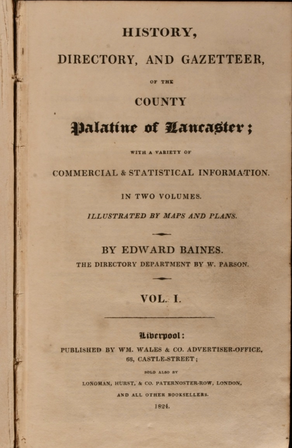
It belonged to Edward Baines’s History, Directory, and Gazetteer of the County Palatine of Lancaster, published by W. Wales & Company in 1824. A contemporary directory history confirms the 1824 William Wales edition, while surviving copies of Baines’s volume describe it as illustrated by maps and plans. [2][3]
That publishing context helps explain the character of the sheet.
This is a map designed to be used.
It contains a reference list of important buildings, district divisions, street detail, docks, canal infrastructure, a view of the Town Hall and Exchange Buildings, civic seals and Liverpool’s arms. It is part street plan, part civic portrait and part statement of a town very conscious of its own expansion. [1]
118,972 PEOPLE — BUT THE BOUNDARY MATTERS
Maps tempt us to attach a single population figure to everything inside the frame.
For 1824 Liverpool, that would be misleading.
The 1821 Census recorded 118,972 people in Liverpool parish: 54,340 males and 64,632 females. [4]
That is the cleanest official figure to use for Liverpool itself.
But Swire’s title says Liverpool and its Environs, and the map deliberately reaches beyond the tightly defined town. Toxteth Park, Everton and Kirkdale complicate any attempt to turn the whole sheet into one population total.
A later official census comparison grouped Liverpool with Toxteth Park and gave their combined 1821 population as 131,801. Toxteth Park alone contained 12,829 people. [5]
Contemporary writers were already complaining that Liverpool’s administrative boundary understated the population of the real urban area. An 1823 guide noted the official parish total of 118,972, then argued that neighbouring places occupied by people whose business was in Liverpool also formed part of the practical town. [7]
So throughout this series we will do something simple but important:
we will say exactly which boundary a population figure describes.
For this map, our headline figure is therefore:
Liverpool parish, 1821: 118,972 people.
For comparison, the same parish had returned 77,653 people in 1801. In only twenty years the total had risen by a little over half. [7]
THE OLD DOCK — TWO YEARS FROM DISAPPEARING
Near the heart of Swire’s plan is a piece of Liverpool that was living on borrowed time.
The Old Dock.
Opened in 1715 on the site of the tidal Pool, it had helped establish the system of enclosed docks that became central to Liverpool’s extraordinary commercial growth. [8]
By 1824 it was surrounded by the expanding town and increasingly unsuitable for the scale of modern shipping.
It closed in 1826 and was filled in. Archaeological work on the site records the last ship leaving on 31 August 1826; the later Custom House was then constructed over much of the site. [9]
Swire therefore gives us the Old Dock not as an archaeological trace or a memory, but as part of the working Liverpool waterfront.
Two years later it was gone.
That is one of the great strengths of historic maps: they can freeze a city immediately before a major change.
PRINCE’S DOCK — THE NEW ARRIVAL
If the Old Dock represents an earlier Liverpool, Prince’s Dock represents the expanding port.
It had opened in 1821, only three years before Swire’s map was published. Later descriptions give it a water area of more than ten acres and show how important it became to the general trade of the port. [10]
On Swire’s sheet, Prince’s Dock sits prominently on the northern waterfront.
This creates a wonderful historical contrast on a single map.
One major dock had just opened. Another was about to close.
Liverpool was not simply getting bigger. Its infrastructure was being replaced, extended and pushed continually along the Mersey.
THE “INTENDED NORTH DOCK” — A FUTURE ALREADY DRAWN
Look farther north and Swire labels an “Intended North Dock.”
This is perhaps the most revealing word on the whole waterfront:
intended.
The map is not only recording what existed. It is showing the direction in which Liverpool expected to grow.
The dock subsequently opened as Waterloo Dock in 1834. By then Clarence Dock, absent from Swire’s working waterfront, had also opened in 1830. [10][11]
So the northern edge of this map is not really an edge at all.
It is a construction line.
The dock estate is already pressing beyond it.
EVERTON IS STILL A SEPARATE PLACE
One of the easiest ways to appreciate the scale of Liverpool’s later expansion is to stop looking at the docks and look inland.
Everton is not swallowed by the city.
On Swire’s map it remains a distinct settlement separated from the dense centre by open land. Houses and long plots occupy the higher ground while fields still interrupt the landscape between Everton and Liverpool. [12]
To modern eyes, accustomed to an unbroken urban landscape, the separation is striking.
And it reminds us what these maps can do better than almost any written description.
They show the city before the gaps disappeared.
THE BOTANIC GARDEN — STILL OUT IN THE FIELDS
To the south-east, another landmark sits in a landscape that feels surprisingly rural.
Liverpool Botanic Garden.
The garden had been formed as a subscription society in 1802 by a group including William Roscoe, William Bullock and doctors John Bostock and John Rutter. Its Mount Pleasant site occupied land between what became Falkner Street and Brownlow Hill Lane. [13]
The Liverpool Botanical Trust records that streets finally reached the garden in the late 1820s. [13]
Swire catches it just before that happened.
The garden appears beyond the tightly packed town, surrounded by open ground. Within only a few years the urban edge would reach it, and increasing development and pollution would eventually help drive the institution to a new site at Wavertree. [14]
Again, 1824 proves to be a hinge point.
THE CANAL REACHES THE EDGE
At the northern side of the town, the Leeds–Liverpool Canal reaches Liverpool through a landscape of yards, industry and increasingly dense development.
Swire makes the relationship between water transport and the growing town unusually clear.
The docks face the Mersey. The canal reaches inland. Between them sits a commercial town becoming more complicated, crowded and connected. [12]
But another transport system is conspicuously absent.
SIX YEARS BEFORE THE RAILWAY AGE
There is no line running east towards Manchester.
No Edge Hill railway complex.
No Crown Street passenger terminus.
No great railway tunnels driven beneath Liverpool.
That world had not arrived.
Parliamentary approval for the Liverpool & Manchester Railway came in 1826. The line opened on 15 September 1830, and Historic England describes the opening as a pivotal moment in the development of the modern mainline railway. [6]
Seen with hindsight, Swire’s Liverpool is therefore almost perfectly timed.
It captures the town before the railway became part of its geography.
Our separate article, Liverpool and the Birth of the Railway Age — Huskisson and 1830, picks up that story six years later.
AND THEN SWIRE PUT 1720 IN THE CORNER
The smallest map on the sheet may carry the biggest message.
At bottom right is an inset titled:
“A Mapp of Leverpoole 1720.”
It compresses an extraordinary century of growth into a comparison that Swire’s original readers could make without turning a page. [12]
The earlier town is compact. The later Liverpool spreads far beyond it. The waterfront has been transformed. Streets multiply. Docks multiply. Institutions and suburbs push outward.
That inset is not an accidental decoration.
It turns the entire sheet into a before-and-after image.
And it tells us something about how Liverpool wanted to see itself in 1824:
as a place transformed by growth.
WHAT SWIRE CATCHES IN ONE SHEET
Read together, the details make 1824 remarkably vivid.
- The Old Dock is still open — but will close in 1826.
- Prince’s Dock is only three years old.
- An Intended North Dock points towards the next phase of waterfront expansion.
- Everton still stands visibly apart from the dense town.
- The Botanic Garden still lies beyond the advancing streets.
- The Leeds–Liverpool Canal reaches the northern edge of Liverpool.
- The Liverpool & Manchester Railway does not yet exist.
- The 1720 inset makes a century of expansion visible at a glance.
And behind all of this is a population already rising quickly: 118,972 people in Liverpool parish at the 1821 Census, before counting Toxteth Park and other adjoining communities separately. [4][5]
WHY THIS MAP MATTERS
A modern map tells you where things are.
A historic map can tell you where change was happening.
Swire’s Liverpool is not the compact eighteenth-century town shown in the 1720 inset.
But neither is it the railway city, Victorian port or immense urban landscape that followed.
It sits between them.
The old dock system and the new dock system overlap. The urban core and surrounding countryside touch. Separate settlements are beginning to feel the pressure of expansion. A railway revolution is only six years away.
That is why 1824 deserves more than a passing Facebook post.
It deserves to be read slowly.
Street by street. Dock by dock. Field by field.
Because on this one sheet, Liverpool is becoming recognisably modern — while an older landscape is still visible underneath.
Citations
Sources & further reading
- [1] Catalogue of British Town Maps — Liverpool 1824: title, survey dates, scale, dimensions, map-maker, engraver, publisher and repository copies. Catalogue record.
- [2] Edward Baines, History, Directory, and Gazetteer of the County Palatine of Lancaster, vol. 1 (1824): publication context for the map and Liverpool section. Google Books.
- [3] Historic Society of Lancashire & Cheshire — Liverpool Directories: records William Wales & Co.’s 1824 directory within Baines’s county history. Read the paper.
- [4] 1821 Census via Vision of Britain: Liverpool parish population 118,972, including male and female totals. 1821 Census table.
- [5] 1841 Census comparative table via Vision of Britain: Liverpool with Toxteth Park, including the combined 1821 figure of 131,801. Comparative population table.
- [6] Historic England — Edge Hill Engine Station: parliamentary approval in 1826 and the opening of the Liverpool & Manchester Railway on 15 September 1830. Historic England.
- [7] The Stranger in Liverpool (1823): contemporary population discussion, including the 1801 and 1821 figures and the problem of defining the practical town beyond the parish boundary. Read the 1823 guide.
- [8] Historic Society of Lancashire & Cheshire — M. K. Stammers: Liverpool’s first dock and its importance to the port’s growth. Read the paper.
- [9] Lancaster University Archaeological Unit / Oxford Archaeology: archaeological history of the Old Dock, including its closure in 1826 and later Custom House development. Old Dock evaluation report.
- [10] Vision of Britain — Liverpool dock descriptions: Prince’s Dock opened 1821 and later dock chronology. Liverpool description.
- [11] Vision of Britain — later dock chronology: Clarence Dock opened 1830 and Waterloo Dock opened 1834. Dock chronology.
- [12] Historic Liverpool — William Swire’s 1824 map: map details including the 1720 inset, canal, Everton and Intended North Dock. Explore the map.
- [13] Liverpool Botanical Trust — creation of Liverpool Botanic Garden: founders, 1802 establishment, Mount Pleasant site and the late-1820s arrival of surrounding streets. Liverpool Botanical Trust.
- [14] Liverpool Botanical Trust — move to Wavertree: the effect of surrounding development and the decision to relocate. Move to Wavertree.
Continue the conversation
Share this Liverpool story
Follow Out in Liverpool or bring your own memories, maps and local knowledge to the Community Group.